End of November 2024, NATO SPS Cube4EnvSec has ended. This SPS flagship project, one of the largest ever funded, has pushed the state of the art in GEOINT and ISR capabilities when it comes to Big Data. Key capabilities like cloud/edge integration, location-transparent federation, AI integration, spatio-temporal analysis on the fly, and - last not least - interoperability have been exercised and demonstrated live. Many of the demos remain online for public access. "In this project, a unique lineup of experts from Germany, Greenland, Israel, Turkey, and the US have teamed up to build something radically new", explains project lead Prof. Dr. Peter Baumann and continues, "now it is up to the civil and defense service operators to enhance their services - the code is ready".
Contact: email Peter Baumann
In May 2024, the GINR Sanna research vessel set sail for a cruise from Nuuk / Greenland. On board was a local server collecting bathymetry data into an onboard datacube. Via federation, realtime comparison was possible with the model bathymetry data of the Nuuk service and CoperniCUBE data from Netherlands.
Chatbots are becoming useful tools supporting daily professional life. Now NATO SPS project Cube4EnvSec unleashes ChatCUBE, an AI designed by the rasdaman team that lends a helping hand in for datacube queries effortlessly and. ChatCUBE gets experts more productive while novices ramp up their skills at their individual pace. This disruptive innovation opens new vistas for empowering users and comprehensive insights into spatio-temporal geo data.
The breakthrough of OpenAI with its ChatGPT has sparked new specialized service, such as SQL trainers. Now a chatbot has been tuned to geo datacube analytics. The rasdaman datacube experts present ChatCUBE, a prototype chatbot assisting in designing datacube queries based on the OGC/ISO standard Web Coverage Processing Service (WCPS). It responds to questions like „explain the basics of WCPS“, „how does datacube fusion work?“, „show me an example of timeseries analysis“, and all the further details of datacube wrangling. First feedback so far is quite encouraging: it “eases query writing” and “wish I had this earlier” was heard from both novices and experts.
"We see ChatCUBE as a very effective productivity tool lowering the barrier for datacube analytics”, explains Prof. Peter Baumann, lead of the rasdaman university research group and spinoff founder, continuing “we must democratize data understanding, get away from the restrictive python barrier limiting access to a circle of programmers”. For beginners, the datacube dialog smoothens the learning curve through individualized learning by giving introduction, explanation, and examples, etc. at the pace and direction of the learner. Experts see a productivity enhancement as they can look up syntax details, obtain query examples and templates for complex queries involving subsetting, analysis, aggregation, fusion, etc.
Cube4EnvSec has has made this service publicly available for free. Users can leave a feedback on how satisfying they found the result, thereby helping to optimize the service further.
TechNet Transatlantic is an AFCEA event for the warfighting community of the US Forces in Europe. TechNet Transatlantic seeks to bring to the forefront ground-breaking technology that leverages the sophisticated use of current and developing capabilities and technologies to determine and, if required, defeat adversaries decisively at a time and place of one's choosing.
In a plenary talk, the Cube4EnvSec Director Prof. Dr. Peter Baumann presented the project and its contribution to "AI Datacubes for Collaborative ISR and Tactical Data Availability at Scale". Supported by live demos the interested audience followed a condensed overview on the new capabilities and their vistas for next-generation GEOINT and beyond.
AFCEA TechNet is a conference series with a focus on force integration and collaboration on the battlefield of today and tomorrow. Ground-breaking technologies, enhanced battlefield digitalisation, and solutions for Joint All Domain C2, Cyber Defence, AI applications in combat etc. are subjects to be displayed and discussed. Networking of partners and also amongst industry and academia is at the core.
The digital carbon footprint makes a significant contribution to the CO2 issue society has today. The pioneer datacube engine, rasdaman, now has been enhanced with the GreenCube® innovation which minimizes energy consumption in Big Data Analytics while retaining full flexibility.
Computers today generate a non-negligible contribution to the overall CO2 release on the planet, known as the "digital carbon footprint". Business transactions, gaming, analytics, AI, etc. all have made computer energy consumption skyrocket. IEEE, like other institutions, has published several articles on this challenge. One angle to attack the problem is the algorithmic efficiency. Python, for example, is what computer scientists call an "interpreted language" meaning the code has to be translated into executable machine language every time again. "Compiled languages" do that once and for all, saving runtime and energy. The rasdaman engine, for example, is implemented in the C++ language which also is known to generate particularly efficient code.
With its proprietary GreenCube® innovation rasdaman now goes one step further: incoming requests get translated directly into machine code - regardless of the request API used, like WMS, WMTS, WCS, WCPS, or OAPI-Coverages. Federated data fusion benefits from this GreenCube method and additionally determines a distributed processing plan which provably incurs only the minimum data transport between the nodes.
Altogether, GreenCube® optimizes the carbon footprint while retaining full flexibility for users; they additionally benefit from the outstanding performance allowing complex analytics in realtime, with location-transparent combination of secured in-house and public EO data.
GreenCube® is being exploited already in a series of ambitious projects. In ORBiDANSe, partly funded by German Ministry for Digital and Tranport (BMDV), rasdaman has shown in-orbit datacube processing on an ESA nanosat.
In AI-Cube, datacube fusion and AI-based analytics has been integrated and demonstrated on large-scale Copernicus datacubes, in collaboration with TU Berlin. Machine Learning prediction now can be invoked seamlessly within the OGC-standardized datacube analytics language, WCPS. The project is partly funded by the German Ministry of Economics and Climate Affairs under grant no. 50EE2012.
FAIRiCUBE has set out to enable players from beyond classic Earth Observation (EO) domains to provide, access, process, and share gridded data and algorithms in a FAIR and TRUSTable manner. The project is funded through Horizon Europe grant 101059238.
Cube4EnvSec exploits Big Earth Datacube Analytics for transnational security and environment protection. A series of use cases proves the capabilities of realtime datacube management, analytics, and federation of fixed and moving data sources and sinks. Cube4EnSvec is partly funded by the NATO Science for Peace and Security (SPS) program.
ISO now has published two fundamental standards for multi-dimensional Big Earth Data, in particular: spatio-temporal datacubes, which significantly advances FAIR data principles.
In standardization, a coverage is the common unifying abstraction for regular and irregular grids (e.g., datacubes), point clouds, and general meshes. Generally, it describes spatio-temporally extended phenomena, similar to "fields" in physics, and effectively bridges raster and vector data types. Two new coverage standards have now been adopted by ISO. 19123-1 "Geographic information — Schema for coverage geometry and functions — Part 1: Fundamentals" describes the concepts and terminology of coverage data. 19123-3 "Geographic information — Schema for coverage geometry and functions — Part 3: Processing fundamentals" does the same for processing through a datacube language allowing simple as well as unlimited complexity, including fusion for insightful data exploration.
Together, these standards establish a critically important basis for interoperability. As a consequence, geographic information becomes more findable, accessible, interoperable, and reusable – in short: FAIR.
The team’s task was to modernize ISO 19123 published in 2005, and technically outdated today. Together with the existing 19123-2 standard for coverage encoding, a modern suite of standards exists now for multi-dimensional data. which forms a firm fundament for coverage and in particular datacubes – which comes just in time as recently diverging, incompatible use of the term have emerged.
These collaborative efforts between ISO TC211, OGC, the IEEE GRSS Earth Science Informatics TC, and international standards developers provide a solid foundation for FAIR data practices in geographic information. OGC already has announced that it will consider adoption of both standards into its mirror standard Abstract Topic 6.
Nato has launched a new multiyear Science for Peace and Security Programme project named Cube4EnvSec which aims at exploiting Big Earth Datacube Analytics for transnational security and environment protection. Its consortium continuously grows, and two additional partners have joined: the Centre for Aviation at ZHAW Zurich University of Applied Sciences in Switzerland and Istanbul Aydin University in Türkiye.
A major challenge for the future is to enable continuous monitoring of climate change and establish early warning capabilities to ensure the security and protection of our populations. Rapid environmental changes call for innovative technological approaches. Essentially, organizations like NATO need advanced capabilities allowing geographically distributed joint mission forces.
In Cube4EnvSec a series of relevant use cases are being established proving the capabilities of real-time datacube management, analytics, and federation of fixed and moving data sources and sinks. Among others an aviation weather service has been started offering the integration of highly dynamic weather data (flight hazards as thunderstorms/lightnings and turbulence) up to the Stratosphere with an update frequency moving towards minutes. It should be mentioned here for aviation stakeholders that this information is also available over data-poor regions (Atlantic, Mediterranean).
(source: NATO/Haboob,Minusma,Bransmoeller)
Now the project will be strengthened and expanded by the Centre for Aviation Zurich University of Applied Sciences. A detailed prediction of parameters relevant for aviation (turbulence, 3D wind, flight hazards) offers enhanced resolution particularly in mountainous regions, based on a high resolution downscaling of existing atmospheric physical models. The trial version - will be implemented in closed cooperation with METAIR in Switzerland. METAIR is a spin-off by alumni of ETH Zurich, with a focus on measurements of anthropogenic and biogenic emission and deposition of Green House Gases (GHG, such as CO2 and CH4) and the detection of ash plumes.
The capability of a substantially improved tactical mission planning of aircraft and Unmanned Aircraft Systems (UAS) will be significantly increased and adapted to mission pattern relevant parameters (i.e., turbulence, wind shear, icing, volcanic ash); furthermore, dispersion predictions (CBRN), simulation and verification with climate scenario models will be improved. A second important contribution will be made by the new partner Istanbul Aydin University in Turkey which focuses on an Integrated Information System (IIS) for high-risk weather phenomena - such as storm and lightning - under different Climate Change scenarios in Mediterranean areas.
The Web-based service information system will integrate GIS and Remote Sensing technologies which are able to model the effects of different Climate Change conditions. Decision support will be given to local authorities; in addition, critical guidelines on severe weather conditions will be provided.
The underlying technology used in all Cube4Envsec use cases is the rasdaman (raster data manager) Big Datacube engine which is proven, mature, and operational on more than 140 Petabyte of satellite and climate data assets. Based on this platform, the Cube4EnvSec service developed will offer a capability which is relevant to NATO and partner nations in both military and civilian contexts.
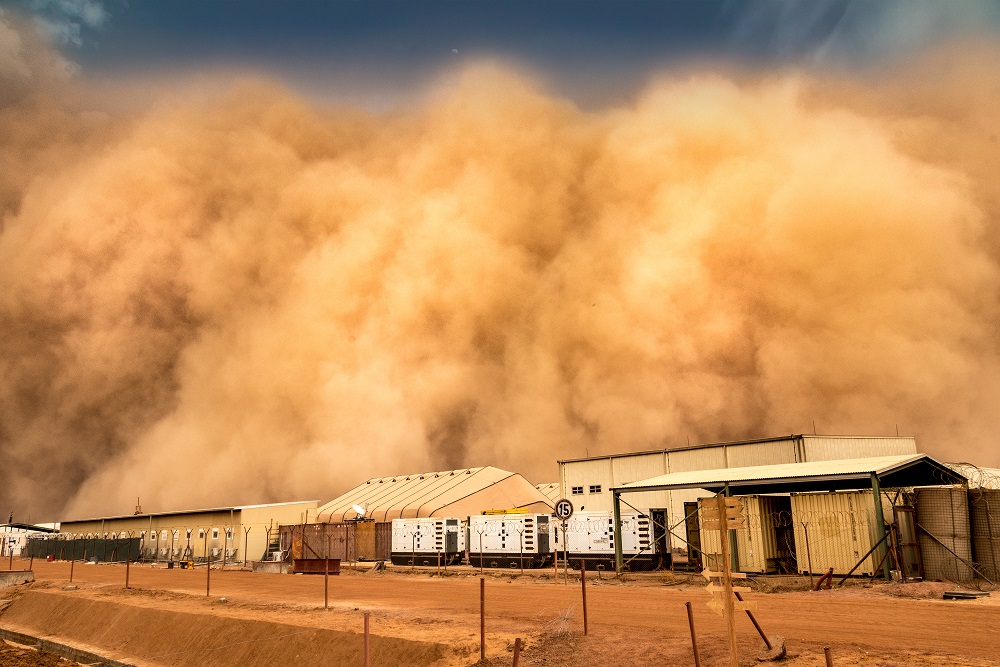
de Peel, Fall 2022 - The NATO C-UAS Exercise 2022 centered around drones and counter-drones. One capability demonstration, by DLR and Constructor University, had a drone fly over an airfield and send down imagery which was fed into a rasdaman datacube in realtime and immediately shown live to the high-ranking audience.
Two capabilities are essential for NATO missions to succeed: first, all units operating off the same map, so sharing the same situational picture, and second, every such unit getting the right data at the right time, and in the right shape.
The C-UAS (Counter Unmanned Aircraft Systems) Technical Interoperability Exercise 2022 (TIE'22) organized by NATO was executed this Fall 2022 at the Lieutenant General Best Barracks in The Netherlands. The Cube4EnvSec project was invited to demonstrate ad-hoc federated mix-and-match and integration of moving data sources into the analytics service, with a focus on aviation. Data acquired live and merged encompassed a DLR drone delivering one image per second, Copernicus Sentinel data from Mundi DIAS, and German Weather Service (Deutscher Wetterdienst, DWD) aviation weather data like wind, temperature, icing, and turbulence. The common information turnpike was provided by the rasdaman datacube engine. "For Intelligence, Surveillance and Reconnaissance (ISR) scenarios, datacubes open up completely new perspectives in availability and usability of all the Big Data sitting around", explains Peter Baumann, Cube4EnvSec project lead.
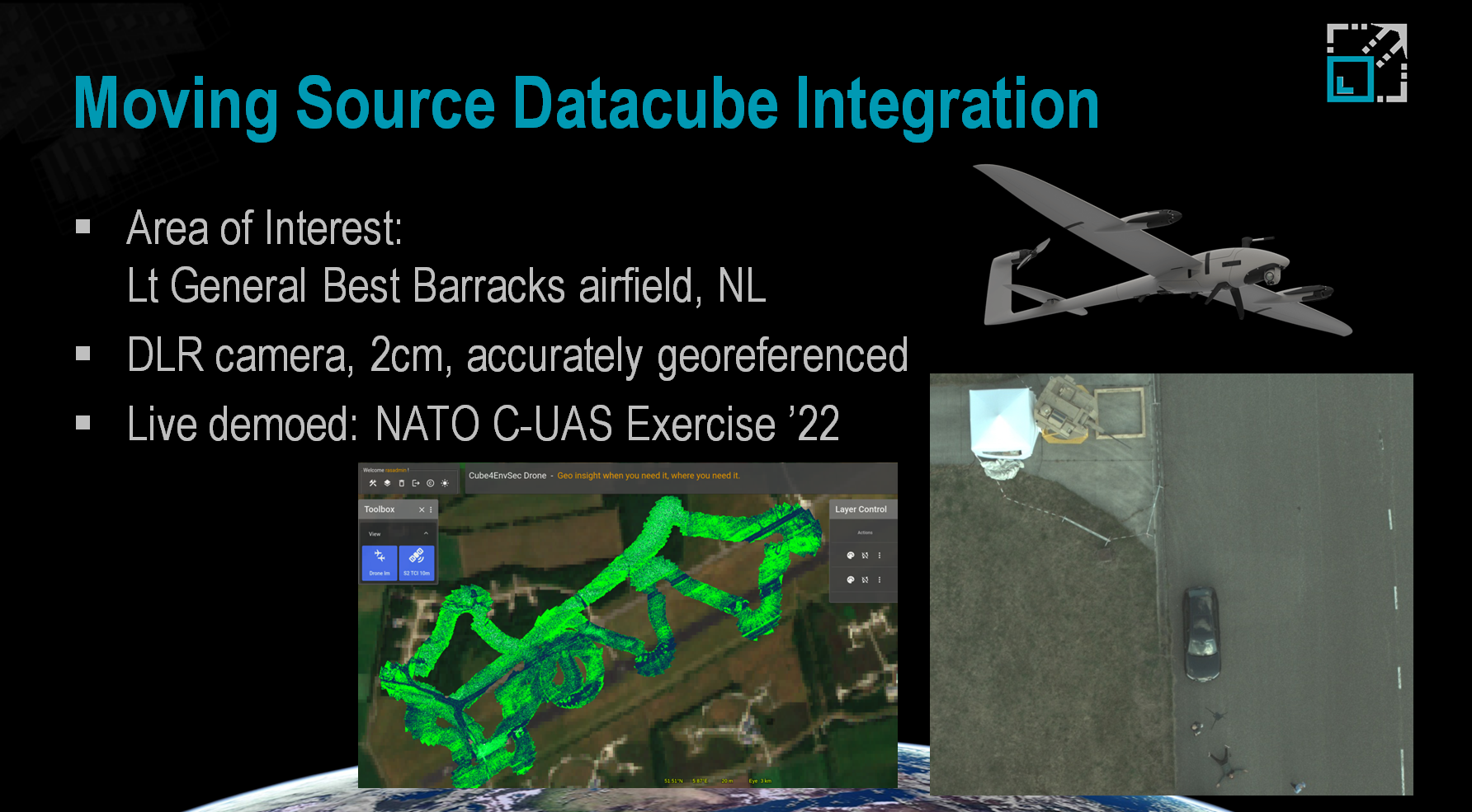
(source: rasdaman, DLR)
The Cube4EnvSec project has set out to demonstrate the value of datacubes as a unifying paradigm for all raster data in domains of environmental monitoring, climate change, and security. The project is funded by the Science for Peace and Security (SPS) Programme of NATO. "Cube4EnvSec is a prime example of how NATO can mobilise the best expertise and knowledge of the scientific community to make a crucial difference", assesses Dr. Jamie Shea, former Deputy Assistant Secretary General for Emerging Security Challenges at NATO Headquarters.
"The new generation of high-resolution, 1 to 10 cm imagery enables the quality and accuracy of procedures such as change analysis for airfields on unstable ground like thawing permafrost, flood simulations, Harbour security in case of sea level rise or land slide risk”, adds LtCol Rene Heise, former Section Head at the NATO Allied Command Operations and member of the Global Military Advisory Council on Climate Change.
rasdaman WCS is the first product to be validated as an INSPIRE complaint Download Service, fully following the requirements laid down for INSPIRE Download Services in both the COMMISSION REGULATION (EU) No 1088/2010 of 23 November 2010 amending Regulation (EC) No 976/2009 as regards download services and transformation services as well as the Technical Guidance for the implementation of INSPIRE Download Services using Web Coverage Services (WCS).
These developments are fully in line with the work done under the INSPIRE Good Practice OGC compliant INSPIRE Coverage data and service implementation, finally enabling the provision of gridded data under the INSPIRE Themes Elevation (EL), Geology (GE), Land cover (LC), Land use (LU), Natural risk zones (NZ), Orthoimagery (OI), Soil (SO) and Energy resources (ER).
This work was supported by Rijkswaterstaat, the Ministry of Infrastructure and Water Management in the Netherlands, who initiated a Proof-of-Concept in which the rasdaman implementation of WCS was utilized for the provision of elevation and bathymetry data. This data was complemented with point-based measurement data (e.g., water levels, precipitation forecast) provided via SensorThings API. This work was done by the cooperation with Sweco and Wetransform GmbH. It has not only proven the feasibility if this solution, but also provided valuable guidance material on all aspects of elevation data provision and use.
Jordi Escriu, Scientific Project Officer at the European Commission Joint Research Centre (JRC), points out the key contribution of rasdaman: "The team involved led the process of implementation of INSPIRE requirements while keeping consistency with these OGC standards" and emphasizes, "This has been a key support for developing the ‘OGC compliant INSPIRE Coverage data and service implementation’ INSPIRE good practice", assuring a technical feasible solution.
In addition to the Web Coverage Services (WCS) and Web Coverage Processing Service (WCPS), OGC supports additional standards for point-based measurements: Sensor Observation Service (SOS) and OGC SensorThings API (STA). Real-world use cases usually require access to both gridded and point based sources, integrating these complementary standards, providing access to different aspect of spatial data measurements.
Kathi Schleidt, consultant on environmental data modelling and founder of Datacove e.U. in Austria, has been deeply involved into the INSPIRE topic, primarily focusing on point-based measurement data. Due to the complementary nature coverage data, these have been extended to her repertoire, providing strong input to the INSPIRE Coverage Good Practice. In recent years she was active in the API4INSPIRE project, where the potential of both the OGC SensorThings API as well as the OGC API - features for use within INSPIRE -has been developed. She says: "I'm looking forward to seeing what interesting and relevant data resources finally becoming accessible now that barriers to use of WCS within INSPIRE have been resolved".
Rapid environmental changes due to climate change call for innovative technological approaches. NATO has started a new project exploiting Big Earth Datacube Analytics for Transnational Security and Environment Protection. The multi-national kick-off meeting in Brussels demonstrates encouraging efforts.
The Sixth Climate Change Assessment Report IPCC published this year points at changes in extremes such as heat waves, heavy precipitation, droughts and tropical cyclones, nowadays registered every month. Cube4EnvSec is a new multi-year NATO Science for Peace and Security (SPS) project which will demonstrate how datacubes can contribute to agile insights on Big Earth Data for observing natural and human-made threats of any kind, combining ground, space, and airborne sources ad-hoc and in real-time. "Cube4EnvSec is a prime example of how NATO can mobilise the best expertise and knowledge of the scientific community to make a crucial difference", assesses Dr. Jamie Shea, former Deputy Assistant Secretary General for Emerging Security Challenges at NATO Headquarters.
(source: Heise)
A series of relevant practical use cases will demonstrate these capabilities. The current non-exhaustive list includes real-time data fusion of on-board aircraft and vessel data sources with large-scale Copernicus satellite archives; thunderstorm warning for aviation; harbor protection and natural resource monitoring over Greenland. "The new generation of high-resolution, 1 to 10 cm imagery enables the quality and accuracy of procedures such as change analysis for airfields on unstable ground (thawing permafrost), flood simulations, harbour security in case of sea level rise or land slide risk”, adds LtCol Rene Heise, former Section Head at the NATO Allied Command Operations and member of the Global Military Advisory Council on Climate Change.
The project utilizes the leading datacube technology, rasdaman, for the sharing of Big Earth Data, with special emphasis on timeseries support, location-transparent federation, and dynamic distributed data fusion across fixed and moving sources. "We aim at unleashing and showcasing the benefits of massive space/time federated datacubes as a particular enabler for better understanding our planet", explains project coordinator Dr. Peter Baumann, Professor of Computer Science in Bremen, Germany. Cube4EnvSec partners are Constructor University (Germany, lead), Tel Aviv University (Israel), and Greenland Institute of National Resources (Greenland/Denmark); further international partners who have expressed an interest to join. LtCol Rene Heise from NATO-HQ acts as Scientific Advisor.
The Cube4EnvSec project is supported by the NATO Science for Peace and Security (SPS) program, with a runtime from May 2022 through October 2023.